Everyone is talking about the Internet of Things (IoT), we think that even ships carrying thousands of tons of cargo are actually “Things”.
The shipping and ports sector has undergone a real revolution in the recent decade following international legislation (motivated by maritime safety considerations), that requires every ship to transmit via VHF transmitter, details on the vessel and its voyage. The system is called: Automatic identification system- AIS.
Those transitions of every vessel bigger than 500 tons are composed of fixed parameters related to the vessel current journey such as the type of ship (tanker, containership, etc.), ports of origin and destination etc., and other variable data such as current GPS location, speed and more. This regulation allows the monitoring of ship traffic around the world.
Most of the global merchant fleet data is collected into huge databases (that are behind payments walls) containing historical information of multiple parameters for approximately 120,000 ships since 2007 to the present day, with billions of rows of information to which millions of rows are added every day.
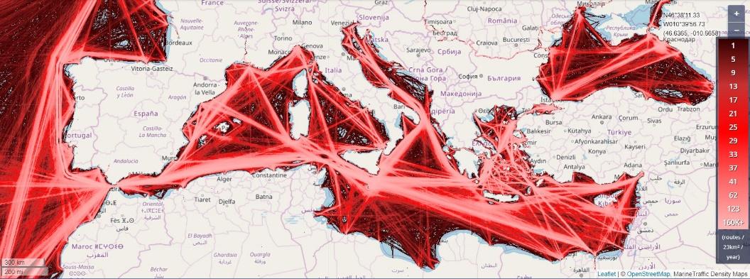
Density map of oil tankers in the Mediterranean Sea
Our project aims to create a dataset of maritime traffic along the Israeli coast-line and in the main Israeli ports (Haifa, Ashdod and Eilat). Data is collected with 3 antennas locates at Haifa university, Ashdod Municipal Maritime Center and The Interuniversity Institute (IUI) for Marine Sciences in Eilat.
Real-time and historical data is freely available for the research community. Data from Haifa antenna is available from June 2021 onwards and from Ashdod and Eilat antenna from January 2022.
Application of data science methods on the dataset can help research effects of sea lanes on the maritime environment, identify trends with geo-political or economic implications, detect unusual activity and much more.
The project is carried out by the Wydra Division for Shipping and Ports, part of the Marine Policy and Strategy Research Center (HMS), (https://hms.haifa.ac.il) and the Department for Maritime Technology under the School of Marine Science, (https://www.marinetech.haifa.ac.il) both at the University of Haifa and funded by the University of Haifa Data Science Research Center.
Project site: http://anlais.haifa.ac.il/@signalk/freeboard-sk/